

News
Bargetracker – Automatic Tow Status Report
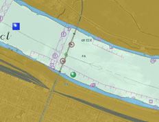 CEACT automatically reports the current tow status including barge IDs, position (lat, lon, river & mile marker), speed and course by email to third-party tracking services like www.bargetracker.com. The program updates the tow information every 15 minutes allowing a semi-real-time tracking of barge status and Movements.
 CEACT is fully compliant with the Internet-based barge tracking service Bargetracker. Bargetracker can automatically
process CEACT tow information like position, speed, course, ETA and towed barge IDs.
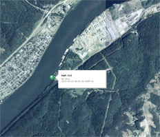
Together with barge positions from positioning devices (GSM, Globalstar and others) and customer‘s individual order information (e.g. orders, destinations, products), Bargetracker provides a comprehensive overview over the current loading positions, status and capacity of the entire fleet. All relevant data are displayed on digital river charts in combination with Microsoft Virtual Earth(R) maps in high-scale resolution.
Further details on www.bargetracker.com.
New Electronic Chart Systems on Board Ingram Vessels
Ingram Barge Company announces the implementation of an innovative electronic chart system by SevenCs called CEACT. CEACT stands for Channel ECDIS, AIS Course Trajectory system, and it uses vector charting. Ingram intends to have the new CEACT systems on board by first quarter 2008.
The vision for Ingram’s new vessel systems includes validating and replacing all technologies on vessels and creating a homogeneous network of systems on board for sustaining safe operation.
All types of vessels were tested for issue management and equipment integrity over a longer period of controlled changes. Of prime consideration were operational fleet safety and completeness of the system.
Ingram donated systems and CEACT donated the navigation software to Seamen’s Church Institute in Paducah, KY, which is fully integrated with the training simulator(s). This will allow pilots to learn the system in a safe environment prior to installation on their vessels.
CEACT is designed with a software developer kit by SevenCs named the ECDIS Kernel. The Kernel is in use by more than 15,000 navigational systems worldwide. SevenCs’ reputation as a professional software manufacturer is based on work in international organizations and their committees such as International Hydrographic Organization (IHO) and the International Maritime Organization (IMO). SevenCs has been instrumental in developing the standards for digital vector charts for the high seas and the inland waterways, and participates in the Harmonization Groups between US and European river authorities. Inland ECDIS software by SevenCs is in use in some 2,800 inland vessels on both continents. SevenCs is a sister company of the UK Hydrographic Office which is one of the world’s premier suppliers of navigational charts and publications. For more information, visit www.sevencs.com. Contact: sales@sevencs.com.
Ingram Marine Group describes Ingram’s operating units involved in transporting bulk commodities on America’s inland waterways, dredging sand, terminaling bulk commodities, and delivering fuel and supplies to the towing industry. The largest of the operating units is Ingram Barge Company, which transports coal, aggregates, grain, fertilizer, ores, alloys, steel and chemicals with a fleet of more than 100 towboats and nearly 4,000 barges, the largest in the industry. Other units include Ingram Materials (sand dredging), Custom Fuel Services (diesel fuel and supplies), Triangle Fleet (ship anchorage in Louisiana), and several bulk commodities terminals in Florida, West Virginia and Tennessee. For more information, visit www.ingrambarge.com.
CEACT Solutions for 2008
The pioneer of Channel ECDIS, AIS and
Course Trajectory , CEACT Information
Systems, Inc., will introduce several new
products in the first half of 2008. CEACT
TRio, CEACT Classic, and BargeTracker
Internet products are designed to leverage
the latest satellite and terrestrial-based
wireless solutions to improve the efficiency
of Inland Waterway Transportation.
There has really been a strong interest in
Channel ECDIS the past, year says Greg
Dunkle, President of CEACT Information
Systems. Multiple land-based sites were
deployed in the past 12 months to monitor
vessel traffic using remote AIS receivers on
the waterways.
Our BargeTracker Internet service provides
a unique barge and ship tracking server
solution, which allows their position, status,
and commodity types to be tracked,
mapped, and archived based on the
customer requirements. Bargetracker can
provide a primary and a redundant solution.
More information about BargeTracker is
available at www.ceact.com or
www.bargetracker.com.
CEACT TRio is a new feature-packed,
affordable Electronic Chart solution
designed for smaller workboats. It contains
the same AIS Channel CPA, Course
Trajectory, and Display Graphics that have
made CEACT chartware the most widely
used Channel Navigation solution in North
and South America.
Upgraded CEACT Classic and new CEACT
TRio products will be available in a few
weeks along with a new downloadable chart
feature at our website, (www.ceact.com)
Pilots will be able to download the most up
to date, secure, digitally encrypted
directENC® chart packages, which are
originally produced in S57 format by
NOAA and USACE. Secure digital
encryption is important because it prevents
tampering of the Open Source S57 data.
The directENC® Chart packages are
optimized to simplify their management,
and formatted using an IMO ECDIS type
approved conversion process, which
preserves the original S57 content produced
by USACE and NOAA.
DirectENC® Chart Packages and updates
produced for the U.S. Market may be
downloaded free of charge during and
throughout the subscription period of
CEACT Trio or CEACT Classic products at
www.ceact.com.