

Key Features of CEACT Classic
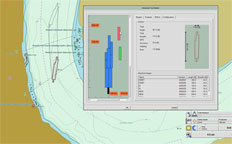 Advanced Tow Builder
Pilots can quickly choose individual barges from CEACT Classic's internal barge database and place them anywhere in the tow, even on the hip. Custom barges and even corporate barge database information can be added. Scale units can be configured in feet and inches or meters.
 Powerful Chartware Data Recorders
System logs from GPS, AIS, and depth sounders are continuously recorded to the system disc using CEACT's trouble free Feed and Release solution. Data is purged from the system disc per user specifications.
CEACT Classic also includes an On the Fly recorder to capture short data segments, and a special Geographically X-Y-Z Corrected Depth Sounder Recorder. All three recorders can be initiated individually or all at once. Historical data can be retrieved and replayed at 1X or 8X speed using the standard playback features in CEACT.
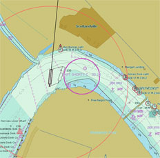
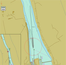 REAL TIME COURSE TRAJECTORY
One of the most important elements in CEACT Classic, this feature is used by line boat pilots operating on major inland waterway routes in North and South America and South East Asia, and is computed in real time using data that is provided by GPS based heading compasses. Any measurable force that acts on the vessel including wind, water current, steering or propulsion affects the vessel’s course trajectory.
The Real Time Course Trajectory feature in CEACT Classic is credited with increasing vessel speed and efficiency, reducing fuel consumption, reducing weather delay, as well as reducing the stress level on pilots when operating in areas of restricted manoeuvrability.
CEACT Classic is built on the powerful, IMO compliant EC2007 ECDIS Kernel from SevenCs.
Resellers
For sales, installation and support, please see our list of
CEACT authorized Value Added Resellers.